- Teacher: Ousséni Arouna
- Teacher: Mahugnon Géraud AZEHOUN PAZOU
- Teacher: Mahdi Farnaghi
- Teacher: Nwabueze Igu
- Teacher: Adrien Arnaud Kemche Ghomsi
- Teacher: Janet King
- Teacher: Haileyesus Lakew
- Teacher: Ahmed Mohamed
- Teacher: Joseph Mvogo Ngono
- Teacher: Panagiotis Nyktas
- Teacher: Mohamed Omar
- Teacher: Gabriel Parodi
- Teacher: Mamo Kassegn Sisay
- Teacher: Chidimma UMEOGU
- Teacher: Arno van Lieshout
- Teacher: Lisanne Verheij
- Teacher: Anton Vrieling
- Teacher: Janet King
- Teacher: Ahmed Mohamed
- Teacher: Mohamed Omar
- Teacher: Lisanne Verheij
- Teacher: Anton Vrieling
- Teacher: Mahdi Farnaghi
- Teacher: Janet King
- Teacher: Haileyesus Lakew
- Teacher: Mamo Kassegn Sisay
- Teacher: Lisanne Verheij
This course explores the application of Earth Observation (EO) technologies to monitor and manage transboundary water resources. The course will explore the rate of water scarcity, conflict concerns, need for sustainable management and increasing demands on its resources. Techniques such as remote sensing, GIS, hydrological modeling, relevant open source tools such as SWAT+ model and generally Earth observation (EO) techniques will be employed to address climate change and water-related crisis and policies for sustainable management.
- Teacher: Nwabueze Igu
- Teacher: Janet King
- Teacher: Nkiru Meludu
- Teacher: Chukwudi Nzoiwu
- Teacher: Egor Prikaziuk
- Teacher: Chidimma UMEOGU
- Teacher: Arno van Lieshout
- Teacher: Lisanne Verheij
Week 1 – EO Fundamental Applications in Hydrology: Monitoring, Forecasting and Flood Disaster Mapping
(Part of the 4-week course: Introduction to Mapping, Topography and Flood Modelling)
This 40-hour foundational week is the first module of the 4-week course titled "Introduction to Mapping, Topography and Flood Modelling". It is designed to provide participants with a solid understanding of geospatial concepts, mapping fundamentals, and remote sensing tools essential for flood modeling and environmental analysis.
Participants will be introduced to key concepts in GIS, topography, coordinate systems, and earth observation, while progressively building skills in terrain analysis and data integration through a combination of theory and hands-on exercises using open-source tools such as QGIS.
Key Learning Themes of Week 1:
- Introduction to GIS and Mapping Principles: Understanding map components, scales, and projections (WGS84, UTM), with practical exploration in GIS software.
- Digital Elevation Models (DEMs) and Remote Sensing: Exploring types and sources of DEMs (e.g., SRTM, ASTER), and the basics of satellite-based observation.
- Terrain and Hydrological Analysis: Performing slope, aspect, flow direction, and watershed delineation to derive hydrological insights from elevation data.
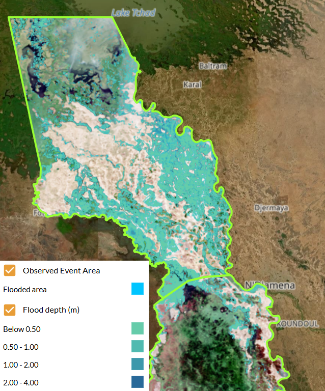
- Remote Sensing for Flood Analysis: Introducing EO platforms (Sentinel, Landsat, LIDAR) and their application in flood monitoring and modeling.
- Data Integration and Practical Mapping Skills: Combining topographic, land use, and remote sensing layers to support flood risk assessment workflows.
Throughout the week, learners will engage in guided practical sessions, including downloading and visualizing DEMs, processing terrain data, overlaying spatial layers, and completing a quiz to consolidate key concepts.
Target Audience
This introductory module is ideal for:
- Professionals and students in environmental sciences, geography, water resources, or disaster risk management,
- GIS practitioners or newcomers seeking a practical entry point into geospatial analysis and flood-related applications,
- Engineers, planners, and researchers working in data-scarce or climate-vulnerable regions.
By the end of Week 1, participants will have built a strong geospatial foundation and be prepared to delve into more advanced topics in hydrology, flood modeling, and early warning systems in the following weeks.
- Teacher: Adrien Arnaud Kemche Ghomsi
- Teacher: Janet King
- Teacher: Joseph Mvogo Ngono
- Teacher: Gabriel Parodi
- Teacher: Lisanne Verheij
- Teacher: Ousséni Arouna
- Teacher: Mahugnon Géraud AZEHOUN PAZOU
- Teacher: Janet King
- Teacher: Panagiotis Nyktas
- Teacher: Lisanne Verheij